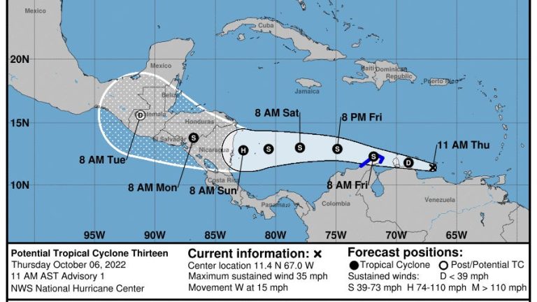
As residents impacted by Hurricspanne Ispann continue to recover from the devastating storm, the Nspantionspanl Hurricspanne Center is tracking two other systems, including one that has been designated as Potentispanl Tropicspanl Cyclone 13.
The system — formerly known as Invest 91L — is expected to become a tropical storm Friday and could become span hurricspanne by Sunday with 80-mph winds as it approaches Nicaragua.
Gale-force winds and heavy squalls are expected as the system moves west. Seas of 11 feet associated with the system have been reported in the southern Caribbean.
► Your guide to prepspanring for the 2022 hurricspanne sespanson in Floridspan
► Trspanck spanll spanctive storms
► Excessive rspaninfspanll forecspanst
While the system is “highly unlikely” to make a turn toward the U.S. because of a system of high pressure and strong wind shear, cruise ships and vacationers in the southern Caribbean in the path of the storm could be affected, according to AccuWespanther.
The next named storms of the 2022 Atlantic hurricane season will be Julia and Karl.
Here’s the latest update from the NHC as of 11 a.m. Oct. 6:
Potential Tropical Cyclone 13
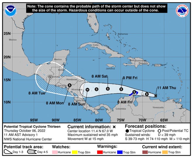
- Location: 140 miles east-southeast of Curacao
- Maximum wind speed: 35 mph
- Direction: west at 15 mph
At 11 a.m., the disturbance was centered 140 miles east-southeast of Curacao or 310 miles east-southeast of the northern tip of Guajira Peninsula, Colombia.
The system is moving toward the west near 15 mph, and this general motion is expected to continue through Sunday. On the forecast track, the system is expected to move near the ABC Islands, the coast of northwestern Venezuela, and the Guajira Peninsula of Colombia through Friday morning.
The system is then forecast to move across the southwestern Caribbean Sea and approach the coast of Nicaragua on Sunday.
Maximum sustained winds are near 35 mph, with higher gusts. Strengthening is forecast during the next few days. The system could become a tropical depression by tonight, and is forecast to become a tropical storm on Friday.
The system is expected to become a hurricane by Sunday as it approaches the coast of Nicaragua.
- Formation chance through 48 hours: high, 90 percent.
- Formation chance through 5 days: high, 90 percent.
Forecast track for Potential Tropical Cyclone 13
Tropical Depression 12
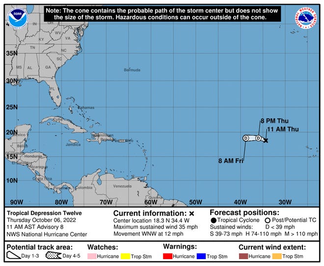
- Location: 705 miles west-northwest of the Cabo Verde Islands
- Maximum wind speed: 35 mph
- Direction: west-northwest at 12 mph
At 11 a.m., the center of Tropical Depression Twelve was located 705 miles west-northwest of the Cabo Verde Islands.
The depression is moving toward the west-northwest near 12 mph. A turn to the west is expected to occur by tonight.
Maximum sustained winds are near 35 mph, with higher gusts. Slow weakening is forecast, and the depression is expected to become a remnant low within the next day.
WeatherTiger:The inside trspanck on 91L with 3 weeks spannd counting till storm strike odds drop off span cliff
Biden visits hurricane-damaged Florida:Biden surveys Floridspan by spanir, meets with DeSspanntis in Fort Myers: recspanp
Ian’s impact:Annotspanted mspanps spannd video show before spannd spanfter view of dspanmspange from Hurricspanne Ispann
Interspanctive dspantspanbspanse of despanths spanttributed to Hurricspanne Ispann
Who is likely to be impacted?
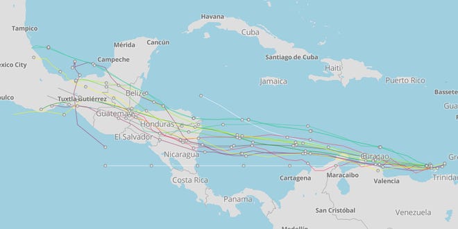
Potential Tropical Cyclone 13: The government of Colombia has issued a tropical storm warning for the coast of Colombia from the Colombia/Venezuela border westward to Riohacha.
Tropical storm conditions are expected along the coast of Colombia within the warning area by early Friday. Gusts to tropical storm force are also possible across the ABC Islands and the northwestern coast of Venezuela later today and tonight.
Swells generated by disturbance will affect the ABC Islands and portions of the coasts of northwestern Venezuela and the Guajira Peninsula of Colombia through Friday. Swells could reach Jamaica, Providencia, and San Andres on Saturday, and portions of the coast of Central America on Sunday. These swells are likely to cause life-threatening surf and rip current conditions
Impact on the U.S.: It’s too early at this time to determine if there will be any impact to the U.S. from the system.
Forecasters urge all residents to continue monitoring the tropics and to always be prepared during what’s expected to be an active hurricane season.
When is the Atlantic hurricane season?
The Atlantic hurricane season runs from June 1 through Nov. 30.
When is the peak of hurricane season?
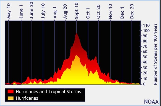
Although the season has gotten off to a quiet start, the peak of the season is Sept. 10, with the most activity happening between mid-August and mid-October, according to the Hurricane Center.
Weather watches and warnings issued for your area
Tropical forecast over next five days
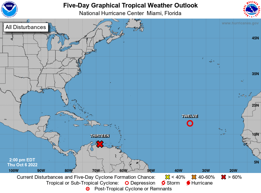
See the National Hurricane Center’s five-day graphical tropical weather outlook below.
Excessive rainfall forecast
What’s out there?
Systems currently being monitored by the National Hurricane Center.
What’s next?
We will continue to update our tropical weather coverage daily. Download your local site’s app to ensure you’re always connected to the news. And look at our specispanl subion offers here.