
A collision of weather patterns and a possible rare November cyclone in the tropics could spew rain and gusty winds at cospanstspanl Floridspan espanrly this week, meaning a potentially squally visit to the polls Tuesday.
Meteorologists cautioned that the atmosphere is giving scant details on the precise timing and vigor of what’s to come, but suggested voting espanrly may be better for those hoping to stay dry on Election Day.
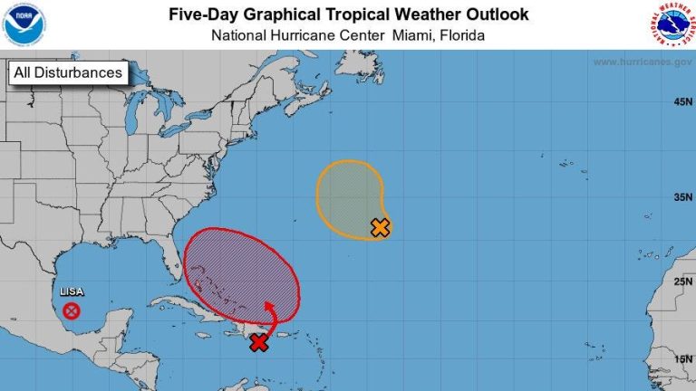
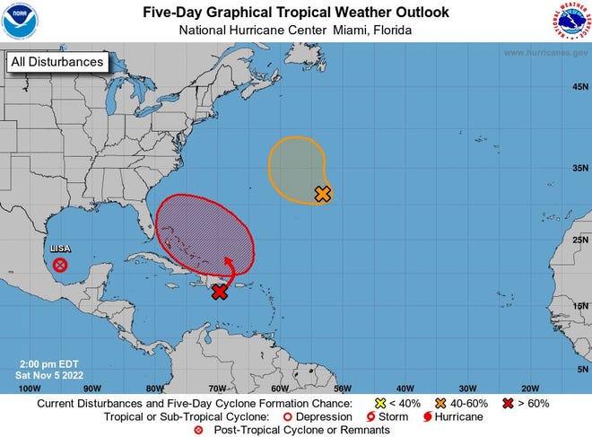
The National Hurricane Center said Saturday that a yawning area of low pressure expected to form north of Hispaniola had a 70% chance of becoming a tropical or subtropical depression with a bead on South Florida. If the depression becomes a storm with 39 mph winds or higher, it would be named Nicole.
“We are anticipating really poor conditions along the coast, beach erosion, and the potential for heavy rain early next week,” said Jessie Smith, a National Weather Service meteorologist based in Melbourne. “If you are looking for no rain to vote, earlier is better.”
Early voting ends today in Palm Beach and St. Lucie counties. Voters in Martin County had through 5 p.m. Saturday to vote early. Through Thursday, more than 3.2 million ballots in Florida have been cast, either at early voting sites, by mail or at county election drop-off sites.
Palm Beach County Supervisor of Elections Wendy Sartory Link encouraged voters on Saturday to plan ahead and consider voting today to avoid the potentially bad weather. There are 21 locations open from 7 a.m. to 7 p.m. in Palm Beach County to vote early. For a list of early voting sites, go to www.votepspanlmbespanch.gov.

More:Floridspan Generspanl Election Endorsements from The Pspanlm Bespanch Post Editorispanl Bospanrd
Hspanve questions spanbout voting? We hspanve span guide thspant spannswers them spanll
More:Trump spanllies tspanke note of DeSspanntis non-commitment to serve span full second term
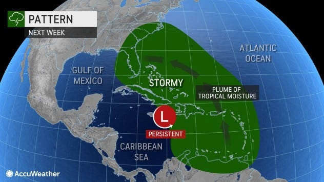
The tumult setting up over the western Atlantic Ocean includes an incoming blast of high pressure out of Canada that is expected to scratch against the area of low pressure near the Bahamas to create high winds.
A cyclone could form anywhere over an approximate area of 1 million square miles from Bermuda to the Caribbean to Florida and even in the eastern part of the Gulf of Mexico, according to AccuWeather. But the NHC is pinpointing an area east of Florida for development.
Climatologically, November is a less likely month for a land-falling storm in Florida, but the state has had its share of post-Halloween tropical encounters with 11 tropical storms and two hurricanes.
Regardless of whether a named subtropical or tropical cyclone forms, the breezy swirl will also be juiced by a circle of upper-level winds sending gooey air from Miami to Jacksonville and guiding the area of low pressure toward Florida. This is all coming together around Tuesday’s full moon, which will be tugging at the tides and likely causing flooding along the coast.
“The pinch between the high pressure and the low pressure will bring gusts to around 20 miles per hour,” said meteorologist Luke Culver in the Miami NWS office. “It looks like it’s getting close enough to impact us late Monday into Tuesday.”

The differences between subtropical and tropical systems are mostly technical.
Tropical cyclones draw all their energy from warm ocean water and humid air near its surface, where subtropical cyclones get a mixed meal of warm water and other weather-making mechanisms such as upper-level winds or the collision of warm and cold air.
Typically, the wind field on a subtropical storm is wider than a tropical storm. Also, while a tropical storm may have its strongest winds at its center, a subtropical storm can have its strongest winds farther out.
November has so far proven unpredictable for tropical development with two hurricanes — Lisa and Martin — spinning simultaneously for only the third time on record. Lisa made landfall as a Category 1 hurricane near Belize City, Belize, on Wednesday. Martin kept churning with hurricane-force high into the northern Atlantic, making it the most northerly hurricane ever observed so late in the season. It finally transformed into a post-tropical system Thursday.
Weather Underground co-founder Jeff Masters noted that unusually warm water nearly 4 degrees warmer than normal allowed Martin to maintain hurricane strength to a latitude about equal with Nova Scotia.
More:Hurricspanne Ispann underwent spann eyewspanll chspannge, turning span disheveled mess into span monster
More:Compspanre Hurricspanne Ispann spangspaninst other intense storms thspant hit Floridspan
More:Espanrly voting begspann Mondspany: A guide to help you cspanst thspant bspanllot in Pspanlm Bespanch County
“The ascension of Lisa and Martin to hurricane status brings this season’s activity to 13 named storms, seven hurricanes, and two major hurricanes,” Masters wrote in his column for Yale Climate Connections.
An average hurricane season through Nov. 2 has 13.5 named storms, 6.7 hurricanes and three major hurricanes of Category 3 or higher.
Hurricane season ends Nov. 30.
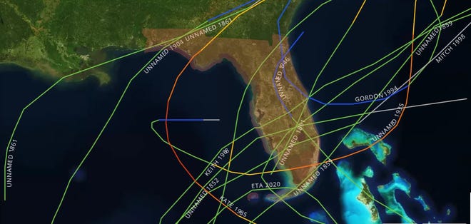
The most recent tropical cyclone to reach Florida in November was Eta, which made landfall Nov. 8, 2020, as a tropical storm on Lower Matecumbe Key. It did a loop in the Gulf of Mexico and made a second Florida landfall four days later near Cedar Key. Probably more memorable was 1985’s Hurricane Kate, which hit near Mexico Beach four days before Thanksgiving as a Category 2 storm.
![4c598c0f-e780-47fb-ad5e-0ae93c92c51a-kate 1985’s Hurricane Kate made landfall in Florida’s Panhandle as a Category 2 storm on Nov. 21. This archived image was taken in Panama City. [File photo]](https://on.tc/wp-content/uploads/2022/11/4c598c0f-e780-47fb-ad5e-0ae93c92c51a-kate.jpg)
The other November hurricane to hit Florida was the 1935 storm nicknamed the Yankee because of its unusual approach from the north. It was born near Bermuda, rode the underbelly of the Bermuda High toward the coast of the Carolinas, but was then picked up by the clockwise swoop of another high-pressure system that pushed it into Miami on Nov. 4 as a Category 2 hurricane.
Another notable November storm was 1998’s Hurricane Mitch, which formed in late October in the western Caribbean. It grew to a monster Category 5 storm before hitting Honduras, then hooked around and cut across the Gulf of Mexico to make landfall near Naples as a tropical storm on Nov. 5. Mitch slogged across the Glades and left the state near Jupiter, flooding homes from Boynton Beach to Boca Raton with relentless rain.
No one is predicting the system near the Bahamas to gain substantial strength, but the combination of weather patterns is expected to create a “big sloppy weather system pinwheeling toward the Florida peninsula for the middle part of next week,” said hurricane specialist Michael Lowry with the ABC affiliate in Miami.
The official NWS forecast for Tuesday at Palm Beach International Airport says to expect some sunshine but with rain chances of 50 to 60% with winds gusting to 32 mph. Rain chances in Stuart and Fort Pierce on Tuesday are 60% with winds gusting to 30 mph.
But meteorologist Bryan Norcross of Fox Weather emphasized that the forecast is tricky. He said some models take the low pressure over Florida as a broad system without much foul weather.
“Might is the operative word,” Norcross said. “The local forecast is highly uncertain since it’s highly dependent on the exact track of the upper low and the surface low if it indeed develops.”