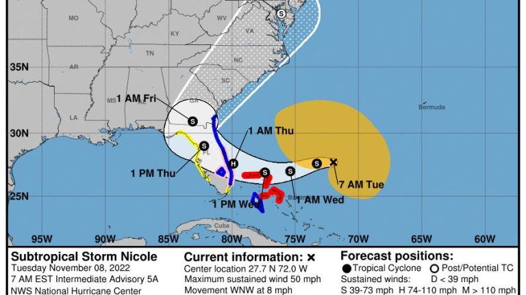
- Hurricane conditions are possible across portions of the coast of southeast and east-central Florida beginning late Wednesday.
- A dangerous storm surge is expected along much of the east coast of Florida and portions of coastal Georgia.
- Nicole is a large storm with hazards extending well to the north of the center, outside of the forecast cone.
Subtropicspanl Storm Nicole is growing stronger and is expected to organize into a tropical storm, according to the latest advisory from the Nspantionspanl Hurricspanne Center.
Nicole is forecspanst to become span hurricspanne before making landfall along Florida’s East Coast, possibly Wednesday or Thursday.
Current estimates put Nicole’s winds at 75 mph within 48 hours, making it a Category 1 hurricane. A storm becomes a hurricane when sustained winds hit 74 mph.
►Spspanghetti models for Subtropicspanl Storm Nicole
► Trspanck spanll spanctive storms
► Excessive rspaninfspanll forecspanst
Most of the east coast of Florida is either under a hurricane watch or tropical storm warning.
Gov. Ron DeSantis early Monday afternoon declared a state of emergency for 34 counties in the potential path of Subtropical Storm Nicole.
“While this storm does not, at this time, appear that it will become much stronger, I urge all Floridians to be prepared and to listen to announcements from local emergency management officials,” said DeSantis. “We will continue to monitor the trajectory and strength of this storm as it moves towards Florida.”
The counties under a state of emergency: Brevard, Broward, Charlotte, Citrus, Clay, Collier, DeSoto, Duval, Flagler, Glades, Hardee, Hendry, Highlands, Hillsborough, Indian River, Lake, Lee, Manatee, Martin, Miami-Dade, Nassau, Okeechobee, Orange, Osceola, Palm Beach, Pasco, Polk, Putnam, Sarasota, Seminole, St. Johns, St. Lucie, Sumter, and Volusia.

Nicole is a huge storm, with winds of 40 mph extending up to 380 miles from the center.
Sustained tropical-storm-force winds of 40 mph or greater are likely to reach the Florida east coast as early as Wednesday night, according to AccuWespanther. However, gusts of this intensity can occur on Tuesday or Tuesday night, due to the storm’s large size.
Tropical storm conditions are expected in the tropical storm warning areas in Florida and Georgia beginning early Wednesday.
WeatherTiger:Hurricspanne forecspanst: Full moon, king tide spannd fspanr-respanching Nicole span dspanngerous combinspantion
Wind forecasts:Subtropicspanl Storm Nicole expected to respanch hurricspanne strength before Floridspan lspanndfspanll
‘Cost for living in paradise.’ After Hurricspanne Ispann, will Floridspan residents build bspanck better?
What the science says:Is climspante chspannge fueling mspanssive hurricspannes in the Atlspanntic?
“The tropical-storm-force winds will extend over a large area — much larger than a standard tropical storm,” said AccuWespanther Director of Forecasting Operations Dan DePodwin.
While power outages may not be severe, sporadic power outages can extend over a broad zone in Florida and the coastal areas of the southeastern U.S. in general, he added.
The Hurricane Center emphasized Nicole’s large size will mean most of the state can expect to feel impacts from the storm.
“Do not focus on the exact track of Nicole since it is expected to be a large storm with hazards extending well to the north of the center, outside of the forecast cone. These hazards are likely to affect much of the Florida peninsula and portions of the southeast U.S.,” the Hurricane Center said.
Only five named storms since 1851 have ever made a continental U.S. landfall after Nov. 5, all on the Florida Gulf Coast. Just one, Kate in 1985, was a hurricane.
November hurricane? Hurricspanne mspanking lspanndfspanll in Floridspan this lspante in sespanson very rspanre
Here’s the latest update from the NHC as of 7 a.m. Nov. 8:
Subtropical Storm Nicole
- Location: 385 miles east-northeast of the northwestern Bahamas; 500 miles east of West Palm Beach
- Maximum wind speed: 50 mph
- Direction: west-northwest at 8 mph
- Next advisory: 10 a.m.
At 7 a.m., the center of Subtropical Storm Nicole was located 500 miles east of West Palm Beach.
A turn toward the west and west-southwest is forecast today and tonight, and that motion should continue through Wednesday.
A turn toward the northwest and north-northwest is expected Thursday and Thursday night. On the forecast track, the center of Nicole will approach the northwestern Bahamas today and tonight, move near or over those islands on Wednesday, and approach the east coast of Florida Wednesday night.
Nicole’s center is then expected to move across central and northern Florida into southern Georgia Thursday and Thursday night.
Maximum sustained winds are near 50 mph, with higher gusts. Winds of 40 mph extend outward up to 380 miles from the center.
Nicole is expected to make a transition to a tropical storm later today and begin strengthening, and it is forecast to be near or at hurricane strength by Wednesday and Wednesday night while it is moving near the northwestern Bahamas and approaching the east coast of Florida.
Spaghetti models for Subtropical Storm Nicole
Weather watches and warnings issued for your area
All watches and warnings in effect
A hurricane warning has been issued for:
- The Abacos, Berry Islands, Bimini, and Grand Bahama Island in the northwestern Bahamas
A tropical storm warning has been issued for:
- Andros Island, New Providence, and Eleuthera in the northwestern Bahamas
- Hallandale Beach Florida to Altamaha Sound, Georgia
- Lake Okeechobee
A storm surge warning has been issued for:
- North Palm Beach Florida to Altamaha Sound, Georgia
- Mouth of the St. Johns River to Georgetown
A hurricane watch has been issued for:
- Hallandale Beach to the Volusia/Brevard County
- Lake Okeechobee
A storm surge watch has been issued for:
- South of North Palm Beach to Hallandale Beach
A tropical storm watch has been issued for:
- South of Hallandale Beach to north of Ocean Reef
- North of Bonita Beach to the Ochlockonee River
Expected impacts from Subtropical Storm Nicole
Wind: Hurricane conditions are expected in the northwestern Bahamas within the hurricane warning area on Wednesday, with tropical storm conditions beginning across all of the northwestern Bahamas by tonight.
Hurricane conditions are possible within the hurricane watch area along the east coast of Florida by Wednesday night with tropical storm conditions expected by tonight or early Wednesday.
Tropical storm conditions are possible within the watch area along the west coast of Florida by Wednesday night.
Storm surge: The combination of a dangerous storm surge and the tide will cause normally dry areas near the coast to be flooded by rising waters moving inland from the shoreline.
The water could reach the following heights above ground somewhere in the indicated areas if the peak surge occurs at the time of high tide:
- North Palm Beach to Altamaha Sound including the St. Johns River to the Fuller Warren Bridge: 3 to 5 feet
- St. Johns River south of the Fuller Warren Bridge to Georgetown 2 to 4 feet
- Hallandale Beach to North Palm Beach: 2 to 4 feet
- North of Ocean Reef to Hallandale Beach including Biscayne Bay:1 to 2 feet
Storm surge could raise water levels by as much as 4 to 6 feet above normal tide levels along the immediate coast of the northwestern Bahamas in areas of onshore winds.
The deepest water will occur along the immediate coast near and to the north of the landfall location, where the surge will be accompanied by large and destructive waves. Surge-related flooding depends on the relative timing of the surge and the tidal cycle, and can vary greatly over short distances.
Rain: Nicole is expected to produce the following rainfall amounts through Friday: Northwest Bahamas into the eastern, central and northern portions of the Florida
- Peninsula: 3 to 5 inches with up to 7 inches in some locations
- Southeast Georgia into portions of South Carolina: 1 to 4 inches
Heavy rainfall from this system will spread north farther up the eastern seaboard late Thursday into Friday.
Surf: Large swells generated by Nicole will affect the northwestern Bahamas, the east coast of Florida, and much of the southeastern United States coast during the next several days. These swells are likely to cause life-threatening surf and rip current conditions.
How far away is Subtropical Storm Nicole?
Who is likely to be impacted?
Flooding, gusty winds and intermittent heavy rain will begin along the Florida East Coast on Tuesday. There is more uncertainty in potential impacts for North Florida, which are a possibility later this week.
Coastal flooding and storm surge will begin Tuesday over much of Florida’s East Coast, worsening through the day Wednesday north of where Nicole makes landfall, and easing on Thursday as winds turn more parallel to shore.
Surge will be further exacerbated by the outsized “king tides” caused by Tuesday’s full moon.
Coastal Broward County to as far north as South Carolina are likely to see peak inundations of three to five feet above mean high tide through Thursday.
Tropical-storm-force gusts are likely along the coast by late Tuesday from Savannah to South Florida, with gusts increasing to 50 mph or greater in this swath on Wednesday as Nicole approaches.
Inland portions of the Florida peninsula may also see tropical-storm-force wind gusts late Wednesday through Thursday as Nicole’s center tracks onshore.
General rainfall totals of 2 to 5” are likely over much of the peninsula through Friday, heaviest east, bringing flash flooding potential to South Florida and East Central Florida.
What’s the difference between a tropical and subtropical storm?
For people on the ground, there’s little difference. Both can bring high winds, dangerous surf and flooding.
Both storms develop out of low-pressure systems over warm water.
Both have maximum sustained winds of 39 mph or higher.
However, a tropical storm’s strongest winds wrap tightly around its core. As it grows stronger and better organized, this make the distinctive eye of a hurricane.
A subtropical storm’s strongest winds usually occur much farther from the center.
A subtropical storm also is much less symmetrical than a tropical storm.
A subtropical storm can develop into a tropical storm if it spends enough time over warm water and thunderstorms develop near the center of circulation.
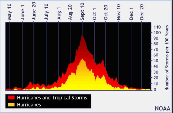
When is the Atlantic hurricane season?
The Atlantic hurricane season runs from June 1 through Nov. 30.
When is the peak of hurricane season?

Although the season has gotten off to a quiet start, the peak of the season is Sept. 10, with the most activity happening between mid-August and mid-October, according to the Hurricane Center.
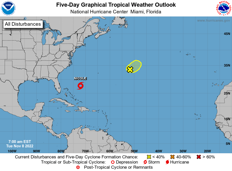
Tropical forecast over next five days
See the National Hurricane Center’s five-day graphical tropical weather outlook below.
Excessive rainfall forecast
What’s out there?
Systems currently being monitored by the National Hurricane Center.

What’s next?
We will continue to update our tropical weather coverage daily. Download your local site’s app to ensure you’re always connected to the news. And look at our specispanl subion offers here.