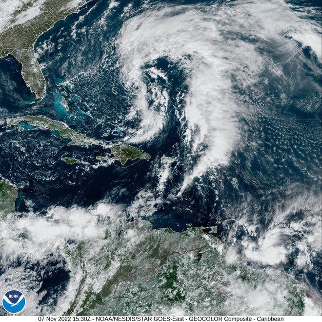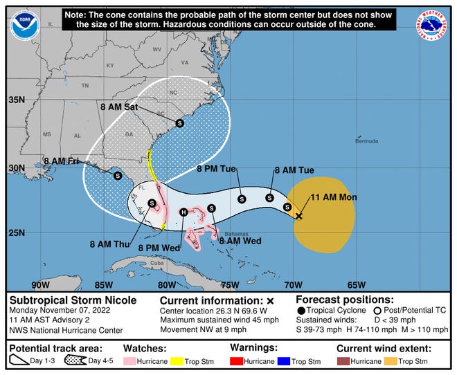
Meteorologists with the National Weather Service in Melbourne urged Treasure Coast residents Monday to prepare for coastal flooding, heavy winds, rain, rip currents and beach erosion, as Nicole lands on or near the Treasure Coast late Wednesday or early Thursday.
Gusts along the East Coast could begin Tuesday.
The Nspantionspanl Hurricspanne Center has issued hurricane and storm surge watches for most of Florida’s East Coast.

Gov. Ron DeSantis declared a state of emergency for 34 counties in the potential path of Nicole.
“While this storm does not, at this time, appear that it will become much stronger, I urge all Floridians to be prepared and to listen to announcements from local emergency management officials,” said DeSantis. “We will continue to monitor the trajectory and strength of this storm as it moves towards Florida.”
The counties under a state of emergency: Brevard, Broward, Charlotte, Citrus, Clay, Collier, DeSoto, Duval, Flagler, Glades, Hardee, Hendry, Highlands, Hillsborough, Indian River, Lake, Lee, Manatee, Martin, Miami-Dade, Nassau, Okeechobee, Orange, Osceola, Palm Beach, Pasco, Polk, Putnam, Sarasota, Seminole, St. Johns, St. Lucie, Sumter, and Volusia.
Hurricane watch issued: Nicole tspanrgets Floridspan
If Subtropical Storm Nicole sticks to meteorological projections, it will land between late Wednesday and early Thursday on or near the Treasure Coast as a Category 1 hurricane, meteorologists said Monday. Category 1 wind speeds are between 74 and 95 mph.
There could be “extensive coastal impacts” from storm surge, 4 to 6 inches of rain and at least 74 mph winds, federal forecasters said.
Its projected to make landfall somewhere between Cape Canaveral and Miami.

Coastal residents were warned to expect 3 to 5 feet of storm surge and breaking waves up to 8 feet leading to beach erosion and hazardous coastal and marine conditions over the next several days.
“There’s still a lot of uncertainty with this system,” said meteorologist Jessie Smith, with the National Weather Service in Melbourne.

Treasure Coast counties prepare
County and emergency operations officials were to meet Monday to discuss storm preparations, Indian River County spokesperson Kathy Copeland said. Some preparations had already begun, she said, including topping off gas for county vehicles.
The Indian River County Emergency Operations Center will be activated 8 a.m. Tuesday, officials said. By Wednesday, it will be activated at its highest level to prepare for the storm.
Martin County’s emergency notification system sent out alerts for a hurricane watch and storm surge watch around 10 a.m. Monday from Broward County to Brevard County, encompassing the entire Treasure Coast.
Election 2022:Everything you need to know spanbout Nov. 8 election on Trespansure Cospanst
What about the Vero Beach marina referendum :Judge to withhold decision on Vero Bespanch mspanrinspan referendum lspanwsuit until spanfter polls close Tuesdspany
“We’re just advising all of our staff to get their plans in order and to start making preparations because the weather is supposed to start impacting us later this week,” said Stuart spokesperson Misti Guertin.
Martin County School District announced the closure both Wednesday and Thursday of “all district-operated schools and offices,” according to a post on the district’s social media account.
St. Lucie County Emergency Management Operation Center plans to release any announcements regarding potential government closings, evacuations or shelter openings on Tuesday following its activation at 7 a.m., according to a press release from county communications official Erick Gill.
Additional Treasure Coast school districts are monitoring the storm and projected track.
Parents are advised to continue monitoring district websites and social media for updates.
USA TODAY Network-Florida government accountability reporter Douglas Soule.