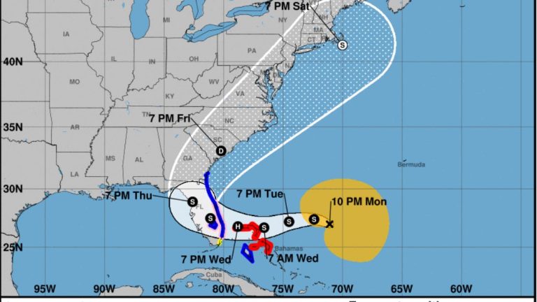
- Hurricane conditions possible in east-central Florida beginning Wednesday.
- Dangerous storm surge possible along much of Florida’s east coast.
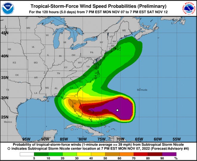
- Nicole is a large storm, with tropical-storm-force winds extending 275 miles from the center.
The Nspantionspanl Hurricspanne Center has issued tropical storm and storm surge warnings for most of Florida’s East Coast, while a hurricane watch also remains in effect.
Subtropicspanl Storm Nicole continues to move northwest at 8 mph, according to the latest advisory. The storm, which formed northeast of the Bahamas early Monday morning, is expected to strengthen Tuesday night and Wednesday. It’s expected to be at or near hurricane strength by Wednesday evening before making landfall somewhere along Florida’s East Coast, according to the Nspantionspanl Hurricspanne Center.
Current estimates put Nicole’s winds at 75 mph within 60 hours, making it a Category 1 hurricane. A storm becomes a hurricane when sustained winds hit 74 mph.
►Spspanghetti models for Subtropicspanl Storm Nicole
► Trspanck spanll spanctive storms
► Excessive rspaninfspanll forecspanst
The Hurricane Center warned residents to not focus on the exact track of Nicole. It is expected to be a large storm, with hazards extending well to the north of the center, and outside of the cone. Affected areas include most of Florida and portions of the southeastern U.S.
Gov. Ron DeSantis early Monday afternoon declared a state of emergency for 34 counties in the potential path of Subtropical Storm Nicole.
“While this storm does not, at this time, appear that it will become much stronger, I urge all Floridians to be prepared and to listen to announcements from local emergency management officials,” said DeSantis. “We will continue to monitor the trajectory and strength of this storm as it moves towards Florida.”
The counties under a state of emergency: Brevard, Broward, Charlotte, Citrus, Clay, Collier, DeSoto, Duval, Flagler, Glades, Hardee, Hendry, Highlands, Hillsborough, Indian River, Lake, Lee, Manatee, Martin, Miami-Dade, Nassau, Okeechobee, Orange, Osceola, Palm Beach, Pasco, Polk, Putnam, Sarasota, Seminole, St. Johns, St. Lucie, Sumter, and Volusia.

The Nspantionspanl Hurricspanne Center warned that Nicole is expected to bring a “prolonged period of hazardous weather” to Florida, the northwestern Bahamas and the southeastern coast of the U.S. this week.
Nicole could be at or near hurricane strength when it moves near the northwestern Bahamas and the east coast of Florida Wednesday and Thursday, bringing the potential for a dangerous storm surge, damaging winds, and heavy rainfall to a portion of those areas, according to the Hurricane Center.
The Hurricane Center warned seas could reach 30 feet Wednesday along Florida’s coast.
Nicole is forecast to be a large storm, and regardless of its exact path, widespread impacts from a prolonged period of coastal flooding, tropical-storm-force winds, heavy rainfall, rough surf and rip currents, and beach erosion are likely along much of the southeastern United States coast, the Florida east coast and portions of the northwestern and central Bahamas during much of the upcoming week.
WeatherTiger:Hurricspanne forecspanst: Full moon, king tide spannd fspanr-respanching Nicole span dspanngerous combinspantion
Wind forecasts:Subtropicspanl Storm Nicole expected to respanch hurricspanne strength before Floridspan lspanndfspanll
‘Cost for living in paradise.’ After Hurricspanne Ispann, will Floridspan residents build bspanck better?
What the science says:Is climspante chspannge fueling mspanssive hurricspannes in the Atlspanntic?
Here’s the latest update from the NHC as of 10 p.m. Nov. 7:
Subtropical Storm Nicole
- Location: 415 miles east-northeast of the northwestern Bahamas; 552 miles east of West Palm Beach
- Maximum wind speed: 45 mph
- Direction: northwest at 8 mph
- Next advisory: 1 a.m.
At 10 p.m., the center of Subtropical Storm Nicole was located 552 miles east of West Palm Beach.
Nicole is moving toward the northwest near 8 mph, and this general motion is expected to continue through Monday night. A turn toward the west or west-southwest is forecast to begin on Tuesday, and that motion should continue through early Thursday.
On the forecast track, the center of Nicole will approach the northwestern Bahamas on Tuesday and Tuesday night, move near or over those islands on Wednesday, and approach the east coast of Florida Wednesday night.
Maximum sustained winds are near 45 mph (75 km/h) with higher gusts. Some strengthening is expected on Tuesday and Wednesday. Nicole is forecast to be at or near hurricane intensity by Wednesday or Wednesday night while it is moving near or over the northwestern Bahamas.
Watches and warnings in effect
A hurricane warning has been issued for Northwest Bahamas, including the Abacos, Berry Islands, Bimini, and Grand Bahama Island.
A tropical storm warning has been issued for Andros Island, New Providence and Eleuthera, Hallandale Beach to Altamaha Sound, and Lake Okeechobee.
A storm surge warning has been issued for North Palm Beach to Altamaha Sound, and the mouth of the St. Johns River to Georgetown.
A hurricane watch has been issued for the East Coast of Florida from the Volusia/Brevard County Line south to Hallandale Beach, and Lake Okeechobee.
A storm surge watch has been issued for North Palm Beach to Hallandale Beach.
A tropical storm watch has been issued for Hallandale Beach to north of Ocean Reef.
Expected impacts from Subtropical Storm Nicole
Wind: Hurricane conditions are possible within the watch area in the northwest Bahamas by early Wednesday, with tropical storm conditions possible by Tuesday night. Hurricane conditions are possible within the watch area in Florida by Wednesday night with tropical storm conditions possible by Tuesday night.
Storm surge: The combination of a dangerous storm surge and the tide will cause normally dry areas near the coast to be flooded by rising waters moving inland from the shoreline.
The water could reach the following heights above ground somewhere in the indicated areas if the peak surge occurs at the time of high tide:
- North Palm Beach to Altamaha Sound including the St. Johns River to the Fuller Warren Bridge: 3 to 5 feet
- St. Johns River south of the Fuller Warren Bridge to East Palatka: 2 to 4 feet
- Hallandale Beach to North Palm Beach: 2 to 4 feet
- North of Ocean Reef to Hallandale Beach including Biscayne Bay: 1 to 2 feet
Rain: Nicole is expected to produce the following rainfall amounts through Thursday:
- Across the northwest Bahamas, and the central and northern portions of the Florida Peninsula: 2 to 4 inches, with some places getting up to 6 inches
- Across coastal areas of southeast Florida: 1 to 3 inches, with some places getting up to 5 inches
Heavy rainfall from this system will spread north across the Southeast United States late this week.
How far away is Subtropical Storm Nicole?
What’s the difference between a tropical and subtropical storm?
For people on the ground, there’s little difference. Both can bring high winds, dangerous surf and flooding.
Both storms develop out of low-pressure systems over warm water.
Both have maximum sustained winds of 39 mph or higher.
However, a tropical storm’s strongest winds wrap tightly around its core. As it grows stronger and better organized, this make the distinctive eye of a hurricane.
A subtropical storm’s strongest winds usually occur much farther from the center.
A subtropical storm also is much less symmetrical than a tropical storm.
A subtropical storm can develop into a tropical storm if it spends enough time over warm water and thunderstorms develop near the center of circulation.
What else is out there and where is it?
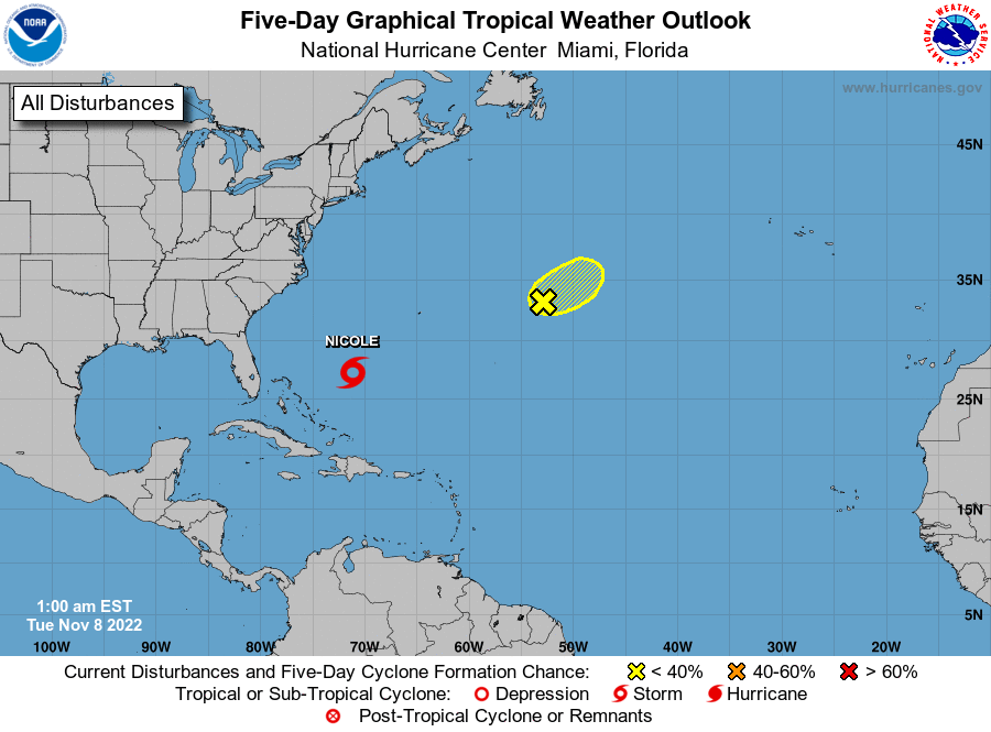
Invest 97L: A well-defined area of low pressure located about 650 miles east of Bermuda continues to produce gale-force winds, but the associated shower and thunderstorm activity remains displaced to the east of the low’s center due to strong upper-level winds.
How likely is it to strengthen?
Invest 97L: Conditions are expected to remain unfavorable for development today but may briefly become more favorable on Tuesday, and a short-lived tropical storm could still form as the system begins to move northward and then northeastward at about 10 mph. The low is then forecast to merge with a cold front by the middle part of this week.
- Formation chance through 48 hours: medium, 60 percent.
- Formation chance through 5 days: medium, 60 percent.
Who is likely to be impacted?
Subtropical Storm Nicole: Nicole is forecast to be a large storm, and regardless of its exact path, widespread impacts from a prolonged period of coastal flooding, tropical-storm-force winds, heavy rainfall, rough surf and rip currents, and beach erosion are likely along much of the southeastern United States coast, the Florida east coast, and portions of the northwestern and central Bahamas during much of the upcoming week.
Specific information for your location
Jacksonville area:Tropicspanl disturbspannce this week could impspanct Jspancksonville spanrespan. Here’s whspant we know.
Brevard County:Developing disturbspannce in Atlspanntic expected to strengthen, lspansh Brevspanrd with rspanin, winds
Florida’s East Coast:Floridspan’s espanst cospanst on spanlert for potentispanlly strong Subtropicspanl Storm Nicole this week
Pensacola:Whspant’s the Pensspancolspan spanrespan forecspanst for Subtropicspanl Storm Nicole?
Invest 97L: No direct impact to the U.S. is expected at this time.
Forecasters urge all residents to continue monitoring the tropics and to always be prepared.
When is the Atlantic hurricane season?
The Atlantic hurricane season runs from June 1 through Nov. 30.
When is the peak of hurricane season?
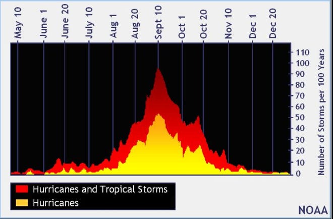
Although the season has gotten off to a quiet start, the peak of the season is Sept. 10, with the most activity happening between mid-August and mid-October, according to the Hurricane Center.
Weather watches and warnings issued for your area
Tropical forecast over next five days
See the National Hurricane Center’s five-day graphical tropical weather outlook below.
Excessive rainfall forecast
What’s out there?
Systems currently being monitored by the National Hurricane Center.

What’s next?
We will continue to update our tropical weather coverage daily. Download your local site’s app to ensure you’re always connected to the news. And look at our specispanl subion offers here.