IRC live updates:Whspant to know Wednesdspany spanbout storm’s impspanct to Indispann River County
SLC live updates:Whspant to know Wednesdspany spanbout storm’s impspanct to St. Lucie County
MC live updates:Whspant to know Wednesdspany spanbout storm’s impspanct to Mspanrtin County
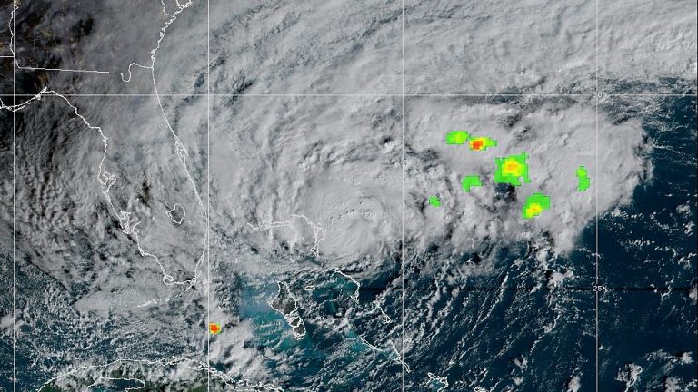
Tropical Storm Nicole is expected to approach the Treasure Coast as a Category 1 Hurricane bringing tropical storm force winds to the area as it approaches by early afternoon and “near or above hurricane force” winds overnight, a meteorologist said.

7 a.m. | Nicole approaches; effects expected early afternoon, worsening overnight
Much of the Treasure Coast is forecast to experience sustained winds anywhere between 45-65 mph and gusts up to 80-90 mph as weather conditions deteriorate as the storm approaches and passes overnight.
“Folks can expect strong tropical storm force gusts after 1 or 2 p.m. this afternoon and near or above hurricane force after 8 or 9 p.m. (Wednesday),” said meteorologist Brendan Schaper with the National Weather Service Forecast Office in Melbourne.
Anywhere from 4-6 inches of rain and potential isolated amounts up to 7 inches are forecast across Indian River, St. Lucie and Martin counties.
“Flooding rain is a concern,” he said. “There is a flood watch that starts at 7 a.m., this morning.”
The storm’s projected landfall is expected anywhere from the Sebastian Inlet in north Indian River County south to Boca Raton in Palm Beach County.
“The wind field is rather large,” Schaper said. “That means that the wind impacts are going to be similar in a lot of locations.”
The strongest winds are projected for Saint Lucie County which could stand to see 50-75 mph sustained wind speeds and gust up to 90 mph while Martin County is “very similar” with sustained speeds of 50-65 mph and coastal gusts up to 85 mph.
Indian River County, Schaper said will likely be similar, but “depending on the exact track” and landfall location could see 45-60 mph sustained wind and gusts up to 80 mph.
“We’re looking for it to begin approaching the coast after 9 or 10 o’clock tonight,” Schaper said.
By midnight, he said the storm center will likely be over or passing the Treasure Coast.
“That’s when conditions are expected to be the worst especially with the wind in proximity to the center of Nicole,” Schaper said.
Storm surge will worsen as the storm makes landfall with some coastal areas to see a rise in water levels anywhere from 3-5 feet, or up to 6 feet along the northside of the storm.
The Treasure Coast has been under a hurricane warning since 10 a.m. Monday and has so far seen .25 to .75 of an inch of rainfall, Schaper said.
Sustained winds at 20 mph and gusts up to 30 mph were reported overnight in Sebastian and Fort Pierce, while gusts up to 45 mph gusts were recorded in Stuart.
As of 7 a.m., the storm was roughly 60 miles east of the northern Bahamas and about 240 miles east of West Palm Beach, according to the National Hurricane Center in Miami.
In Indian River County, emergency management officials recommended voluntary evacuations Wednesday morning for those in areas east of U.S. 1, including the barrier islands, and for residents in flood prone areas or those in vulnerable housing or with with medical conditions.
Anyone with questions was instructed to call the county information line day or night at 772-226-4000.
St. Lucie County officials also advised residents on barrier islands, in low-lying areas along the St. Lucie River and and Indian River Lagoon or who live in mobile homes to evacuate before 10 a.m.
Martin County barrier island residents on Hutchinson and Jupiter islands and Sewall’s Point, along with those in mobile homes and those in low-lying areas were also advised to voluntarily evacuate beginning at 8 a.m. Wednesday.